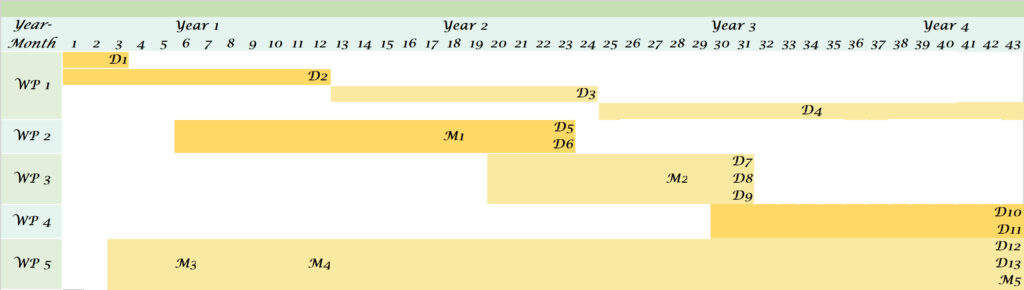
WP Number: 1
WP Title: Management and Organization
Starting Month: 1
Ending Month: 42
Person Months (PMs):42
Objectives
The efficient Organization and coordination of the project activities.
Description of Work
This WP concerns the activities that are necessary for the appropriate management and coordination of the
project.
Task 1.1: Team organization processes
In the 3rd month of the project the PI together with the Advisory Board will prepare an organizational report
that will describe the distribution of tasks and workflows through the different members of the project team.
This report will be used as a reference document within the project team.
Task 1.2: Project Management
The PI together with the Advisory Board will monitor the project activities and will meet regularly (at least
once per month) to resolve potential problems and technical issues that may arise throughout the project
period. The PI will record the progress of the project in annual relevant reports in which the problems
encountered and the solutions provided will be also presented.
Deliverables
D1.1: A report describing the team organization processes (3th month)
D1.2: Annual progress reports (12th month)
D1.3: Annual progress reports (24th month)
D1.4: Annual progress reports (42th month)
WP Number: 2
WP Title: Habitat mapping and Data collection
Starting Month: 6
Ending Month: 23
Person Months (PMs):31
Objectives
Selection of representative river reaches as study areas and data collection for hydrodynamic modeling and
habitat simulation curves for the selected fish species.
Description of Work Physical habitat will be used as the structural feature providing the natural link between the abiotic environment and the biological components. To identify the physical habitats, several types of HydroMorphological Units are typically measured (i.e. pools, runs, riffles, glides, rapids) according to published methods (Dolloff et al., 1993), for the selection of representative river reaches as study areas. Under the framework of this research project the use of an Unmanned Aerial System (UAS), which is comprised by a fixed-wing airplane and high resolution RGB cameras, will contribute to physical habitat identification through the development of detailed Digital Terrain Models (DTMs), under low flow conditions, by applying photogrammetric techniques.
In this way, an efficient, cost-effective, rapid and high spatial resolution alternative or complement will be provided instead of classic labor-intensive monitoring techniques and habitat mapping procedures. In addition, the use of UAS may help to improve classification accuracy for both physical habitat identification and river reaches selection, safely operating even over unfavorable flow conditions. Moreover, an Unmanned Vessel will be constructed that will host acoustic technologies for capturing depth and velocity measurements based on the fish presence spots, combined with a Real-time kinematic (RTK) positioning system, to enhance the precision of position data (up to 1 cm accuracy). For the identification of the fish species, a camera aimed perpendicular to the substrate, will be also attached in the Unmanned Vessel. To ensure comprehensive coverage of the area, the aforementioned new approach will be applied in transects perpendicular to the flow, over the total length of the representative river reaches.
Moreover, techniques which have traditionally been used (i.e. snorkeling, electrofishing) for fish habitat
measurements (Papadaki et al. 2016; Heggenes and Saltveit, 1990; Martínez-Capel et al., 2009) will be also
applied for the validation of the proposed habitat mapping approach.
Task 2.1: Selection of the representative river reaches
The representative river reaches will be selected based on the results of the habitat mapping by ensuring
that the percentage of the different habitat types in the candidate reach is similar to the habitat types
distribution of the entire river reach.
Task 2.2: Data collection
In this project a cutting-edge technology is proposed with the main objective to achieve fast, repeatable and
highly accurate results for the data collection regarding fish habitat measurements. The presence and absence
of selected fish species will be associated with depth, velocity and substrate variables at a microhabitat scale
as part of the fish habitat simulation approach. Substrate data will be also collected based on the dominant
substrate type (within a circumference of 15 cm centered on the fish).
Deliverables
D2.1: A fish habitat database with the requirements of the selected fish species and size classes with respect
to water depth, velocity and substrate type (23th month)
D2.2: A technical report describing the selection of the representative river reaches using UAVs-UVs (23th
month)
Milestones
M1: Digital Terrain Models (DTMs)
WP Number: 3
WP Title: Fish Habitat Suitability Curves and Hydrodynamic Modeling
Starting Month: 20
Ending Month: 31
Person Months (PMs):24
Objectives
Development of the fish Habitat Suitability Curves and the hydrodynamic models.
Description of Work Data analysis will take place for the development of the fish Habitat Suitability Curves and the hydrodynamic
models.
Task 3.1: Habitat Suitability Curves (HSCs)
Statistical elaboration of the collected data (fish presence/absence, water depth and velocity, substrate, etc.)
will occur in R software which will provide the frequency distribution of the fish preferences in terms of water
depth, velocity and substrate for the different seasons, fish species and class sizes. Normalization and model
fitting techniques will be applied to produce the relevant Habitat Suitability Curves (HSCs).
Task 3.2: Hydrodynamic Modeling
Hydrodynamic simulations will be setup in the study areas by using 2D hydraulic models and the associated
in-situ measurements. Different models will be prepared for each season and after calibration and validation processes, several discharge scenarios (from low to high) will be run to capture the respective changes in water
depth and velocity conditions.
Task 3.3: Description of the Physical habitat simulation approach for fish species
This task will be used for the description of the relationships between the stream flow and the physical
habitat for the targeted fish species. The Physical habitat simulation approach used in this project consists of
two parts, the hydrodynamic simulation and habitat simulation. Hydrodynamic simulation computes flow
depth and velocity for specific flow scenarios (in seasonal level for the proposed project) in the study areas,
while habitat simulation evaluates habitat quality based on the species’ preference for each physical variable
(depth and velocity).
Deliverables
D3.1: A technical report describing the development of the fish HSCs (31th month) and
D3.2: A technical report describing the hydrodynamic modeling outputs (31th month)
D3.3: A technical report describing the physical habitat simulation approach for the estimation of fish habitat
requirements (23th month)
Milestones
M3: Fish Habitat Suitability Curves
WP Number: 4
WP Title: Estimation of environmental flows in Greek Rivers
Starting Month: 30
Ending Month: 35
Person Months (PMs):6
Objectives
Evaluation of Weighed Useable Area for different discharge scenarios and for each season for environmental
flow regime estimation
Description of Work
Task4.1: Environmental flow estimation for Greek rivers
Habitat Suitability Curves (HSCs) and the hydrodynamic model outputs (maps with water depth and velocity
for each discharge scenario) will be combined in ArcGIS software to estimate the Weighed Useable Area
(WUA) for each fish species and class size under the different discharge scenarios. The optimal range of
discharge values for each season, fish species and class size will be estimated by using statistical criteria (e.g.
the discharge values providing the highest 20-30% of the Total WUA) and will be used to create hydrologic
guidelines and flow regime estimates that can be used to determine environmental flows.
Task4.2: Update and enhancement of a free relevant tool for the estimation of environmental flows
The new developed habitat suitability curves will be added in a relevant tool for the estimation of
environmental flows with free access to the public, hosted in IMBRIW-HCMR site
(http://imbriw.hcmr.gr/en/tools/).
Deliverables
D4.1: A report presenting the process of deriving environmental flow guidelines (36th month)
D4.2: Update and enhancement of a free relevant tool hosted in IMBRIW-HCMR site (36th month).
WP Number: 5
WP Title: Dissemination
Starting Month: 3
Ending Month: 42
Person Months (PMs):6
Objectives
The development and release of dissemination materials such as a Website, scientific publications, social
media, etc.
Description of Work
Task 5.1: Project’s logo and development of a social media kit
Dissemination of project results is being tailor made and streamlined. At first, a logo will be designed
specifically for FlowTech along with the development of a social media kit. The dissemination of the project
objectives, results and events will be served by web-based mechanisms with state-of-the-art technologies
that maximize web communication.
Task 5.2: Website development and operation
A new website, (in Greek & English) regularly updated (at least 1/month) along with a dynamic webGIS portal
will be developed. Online advertising, promoting the work via internet using banners, google adwords,
facebook, etc. will provide information to the International Community on project’s progress. The webportal
which will start operating 3 months after the beginning of the project will be tested and optimized by the
10th month and will be hosted by HCMR. This procedure will be ongoing throughout the project’s duration.
Task 5.3 Newsletters and publications
The dissemination activities through articles and publications will be carrying on for at least 3 years after the
results of the project, especially for three at least scientific article publications. Newsletters will inform about
both latest project news and forthcoming activities, while press releases will be produced whenever a
significant milestone is achieved (at least 1 per year).
Deliverables
D5.1: Press releases (42th month) Expected results: logo, social
media kit
D5.2: Newsletters (42th month)
Milestones
M3: Logo and Social media Kit
M4: Website go online
M5: 1st Publication submitted